


![[img]](http://www.michael-culture.org/de/2231/1/LWL4.bmp)
 Preview |
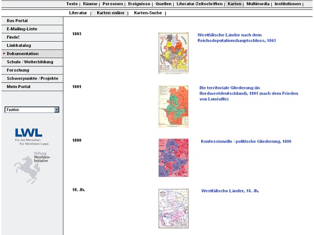
Internet-Portal „Westfälische Geschichte“ (Screenshot)
UNSPECIFIED
Neben digitalisierten Karten u.a. zu den Themen „Politik“, „Bevölkerung“, „Wirtschaft“ und „Konfession“ aus der Literatur, befinden sich zoombare Karten für verschiedene Jahre in dieser digitalen Sammlung. Diese Karten basieren im wesentlichen auf dem am Westfälischen Institut für Regionalgeschichte entstandenen Geschichtlichen Atlas für Westfalen. Weiterhin werden in dieser digitalen Sammlung insbesondere modern bearbeitete Karten zu Themen, Regionen und Territorien in Druckwerken nachgewiesen.
Language:German
Digital Format:HTML, JPEG/JFIF, SVG, GIF image
Digital Type:["digital-type_typename_dt001.1" not defined], ["digital-type_typename_dt001.2.2" not defined], ["digital-type_typename_dt001.5" not defined]
Subject:Kultur
Kultur > Kultur
Kultur > Kulturpolitik und Kulturplanung
Kultur > Geschichte
Kultur > Geschichte > Regionalgeschichte
Politik, Recht und Wirtschaft > Rechtssysteme > Rechtsgeschichte
Sozial- und Gesellschaftswissenschaften
Sozial- und Gesellschaftswissenschaften > Sozialpolitik und Wohlfahrt
Sozial- und Gesellschaftswissenschaften > Bevölkerung
Sozial- und Gesellschaftswissenschaften > Siedlungen und Landnutzung
Sozial- und Gesellschaftswissenschaften > Siedlungen und Landnutzung > Siedlungen
Sozial- und Gesellschaftswissenschaften > Siedlungen und Landnutzung > Landnutzung
Sozial- und Gesellschaftswissenschaften > Siedlungen und Landnutzung > Landschaft
Sozial- und Gesellschaftswissenschaften > Siedlungen und Landnutzung > Offener Raum
Sozial- und Gesellschaftswissenschaften > Siedlungen und Landnutzung > Raumentwicklung
Sozial- und Gesellschaftswissenschaften > Siedlungen und Landnutzung > Ländliche Gebiete
Sozial- und Gesellschaftswissenschaften > Siedlungen und Landnutzung > Ländliche Entwicklung
Sozial- und Gesellschaftswissenschaften > Siedlungen und Landnutzung > Stadtgebiete
Sozial- und Gesellschaftswissenschaften > Siedlungen und Landnutzung > Stadtentwicklung
Politik, Recht und Wirtschaft
Politik, Recht und Wirtschaft > Politik und Regierung
Politik, Recht und Wirtschaft > Volkswirtschaft
Politik, Recht und Wirtschaft > Landwirtschaft
Kultur > Geschichte > Religionsgeschichte
Mittelalter
Mittelalter > Frühes Mittelalter
Mittelalter > Hoch- und Spätmittelalter
Neuzeit bis Gegenwart > 11th century
Neuzeit bis Gegenwart > 12th century
Neuzeit bis Gegenwart > 13th century
Neuzeit bis Gegenwart > 14th century
Neuzeit bis Gegenwart > 15th century
Neuzeit bis Gegenwart
Neuzeit bis Gegenwart > 16. Jahrhundert
Neuzeit bis Gegenwart > 17. Jahrhundert
Neuzeit bis Gegenwart > 17. Jahrhundert > Dreißigjähriger Krieg
Neuzeit bis Gegenwart > 18. Jahrhundert
Neuzeit bis Gegenwart > 19. Jahrhundert
Neuzeit bis Gegenwart > 19. Jahrhundert > Kaiserreich
Neuzeit bis Gegenwart > 20. Jahrhundert
Neuzeit bis Gegenwart > 21. Jahrhundert > Erster Weltkrieg
Neuzeit bis Gegenwart > 21. Jahrhundert > Erster Weltkrieg > Weimarer Republik
Neuzeit bis Gegenwart > 21. Jahrhundert > Erster Weltkrieg > Nationalsozialismus
Neuzeit bis Gegenwart > 21. Jahrhundert > Zweiter Weltkrieg
Neuzeit bis Gegenwart > 20. Jahrhundert > Bundesrepublik (bis 1990) einschließlich Besatzungszonen
Neuzeit bis Gegenwart > 20. Jahrhundert > Deutschland (ab 1990)
Neuzeit bis Gegenwart > 21. Jahrhundert
Mitteleuropäisch
Spatial Coverage: Relationships:| Relation type | Target identifier |
|---|---|
| May be under the responsibility of an institution | LWL - Institut für westfälische Regionalgeschichte [Institution] |
| Is part of (another project or programme) | Internet-Portal „Westfälische Geschichte“ [Digital Collection] |
| May be made available via a product or service | Karten zur Westfälischen Geschichte: Online [Service] |
Actions (login required)
 |
View Item |